
Chirfa Fm
Type Locality and Naming
Its equivalent name of “Felar-Felar” came from a location far from Niger on the western flank of the Amguid Spur Ridge in Algeria. In Niger, it is located east of the Chirfa oasis. Legrand (1993); From the Chirfa oasis, northern Niger.
References: Jacquemont et al., 1959; Jacqué, 1963; Croisile et al., 1963a, 1963b; Beuf et al., 1971; Fabre et al., 1983; Mergl et al., 2000, 2001; Legrand, 1993, 2003, 2011; Denis et al., 2006; Denis et al., 2005, 2007a, 2007b, 2009, 2010; Buoncristiani et al., 2008; Hinsbergen et al., 2011; Shalbak, 2015; Hallet, 2002, 2016; Gutierrez-Marco et al., 2017.
Synonym: *Felar-Felar Fm of Niger (Denis et al., 2006; Denis et al., 2005, 2007a, 2007b, 2009, 2010). Called «Felar-Felar complex» in older Nigerien publications. Legrand (1993) named the “Formation Argilo-Gréseuse de Felar-Felar” of Algeria as “Formation Argilo-Gréseuse de Chirfa” in the Djado of Niger (Fig. 1); Equivalent(s): Felar-Felar Fm of Algeria.
- As mentioned in Fabre et al. (1983) and Legrand (1993), the facies would be the same as Beuf et al. (1971)'s Tamadjert formation in Algeria, which is the same as Legrand et al. (1959)'s “Formation Argilo-Gréseuse de Felar-Felar” of Algeria.
- Upper Member of the Mamuniyat Formation of Libya (compare Fig. 2 with Fig. 3).
[Figure 1: The age of the Chirfa Fm in Niger according to Legrand (2011). The *5 indicates the level at which the graptolites Normalograptus ojsuensis (Koren & Mikhailova) were found.]
[Figure 2: Composite log of the Upper Ordovician–Lower Silurian section from exposures around Murzuq Basin (Modified from El-Hawat et al., 2008). Compare this Libyan section with the Nigerien section in Fig. 3]
 Fig_1.jpg)
 Fig_2.jpg)
Lithology and Thickness
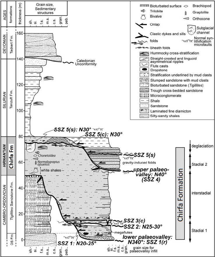
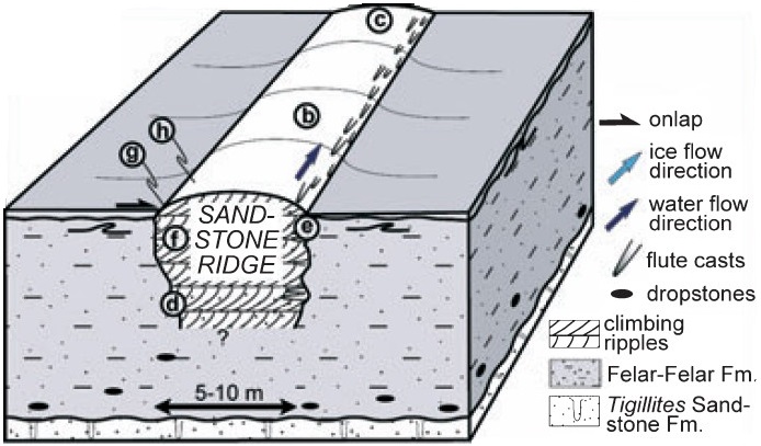
Ochre to green shales, often sandy intercalated with lenses of sandstone beds, sometimes coarse with a cement, often carbonaceous (Legrand, 1993). The Chirfa Fm of Niger comprises lower and upper glacially related complexes (Stadial 1 and 2), separated by non-glacial offshore sediments (Interstadial). Each glacially related complex includes two to three distinct subglacial shear zones (SSZ) (Fig. 3). The formation base is bounded by subglacial shear zone 1 (SSZ 1), while the top is bounded by subglacial shear zone 5 (SSZ 5). The formation is made up of muddy, laminated diamicton with abundant quartz grains and sparse cobbles deforming underlying laminae (dropstones). These facies correspond to glaciomarine conditions, during which clay suspended in seawater was deposited and clasts trapped in calved icebergs, or the base of an ice shelf was released as dropstones. Subglacial shear zones (SSZ 2; Fig. 4) lie within the infill of the lower paleovalley, at least a few meters above its base. A thin muddy diamicton separates SSZ 2 from subglacial shear zone 3 (SSZ 3) in the lower paleovalley infill. SSZ 3 is overlain by muddy diamicton and green-yellow silty to fine-sandy clays and argillaceous sandstones with hummocky cross-stratifications, indicating an open marine storm-influenced, upper offshore depositional environment. The thickest part of the Chirfa Formation consists of these facies of a storm-influenced paleoenvironment, which filled the paleovalley. It indicates a distal environment that rapidly developed in the Djado Basin in conjunction with the major recession (interstadial) separating the two significant ice-sheet advances. The Chirfa Fm indicates that the ice front retreated southwards by 1,000 km. The terminal part of the formation is a thin and muddy diamicton related to the deglaciation and is superimposed by post-glacial shale-dominated distal marine offshore Silurian deposits. The transition from subglacial to offshore environments was thus very rapid and without the development of any transitional sedimentary episode (i.e., fluvial, tidal or wave reworking). Structures corresponding to sandstone ridges are found within the Chirfa Fm (Fig. 5). Sandstone ridges are several meters high, about 10 m wide and hundreds of meters long. Sandstone ridge sedimentological characteristics indicate that sandstone ridges result from the scouring of the Chirfa Fm by sub-glacial, turbulent, and pressurized meltwater; then, subglacial cavities were infilled with sand derived from glacial abrasion. Sandstone ridge networks are comparable with tunnel channels and document unusual drainage structures of the inner part of the paleo-ice sheet. Its thickness is ~80 m.
[Figure 3: Synthetic cross-section of the Hirnantian succession in the Djado Basin, showing the stratigraphic position of sub-glacial shear zones (SSZ) and paleovalleys (Modified from Denis et al. (2007b & 2010) who called the Chirfa Fm, the Felar-Felar Fm). Note 1: Tigillites Sanstone Fm = Hawaz Fm, and "OS Fm" (Oblique Supérieure Fm) = Ash Shabiyat Fm. Note 2: Comparing this image with Fig. 2, the Melaz Shuqran Fm and the lower part of the Mamuniyat Fm of Libya are not present in the Djado Basin.]
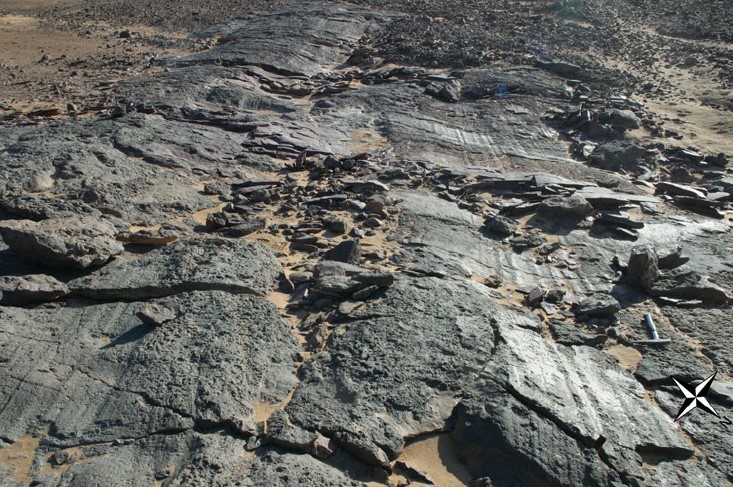
[Figure 4: The ductile SSZ 2 of the Chirfa Formation displays well-expressed glacial linear striations and minor grooves (Source: Denis et al., 2010)]
[Figure 5: Reconstruction of a sandstone ridge within the Chirfa Formation (Source: Denis et al., 2007a)]
Relationships and Distribution
Lower contact
Upper contact
Unconformably overlain by the Tanzuft Fm
Regional extent
Djado Basin
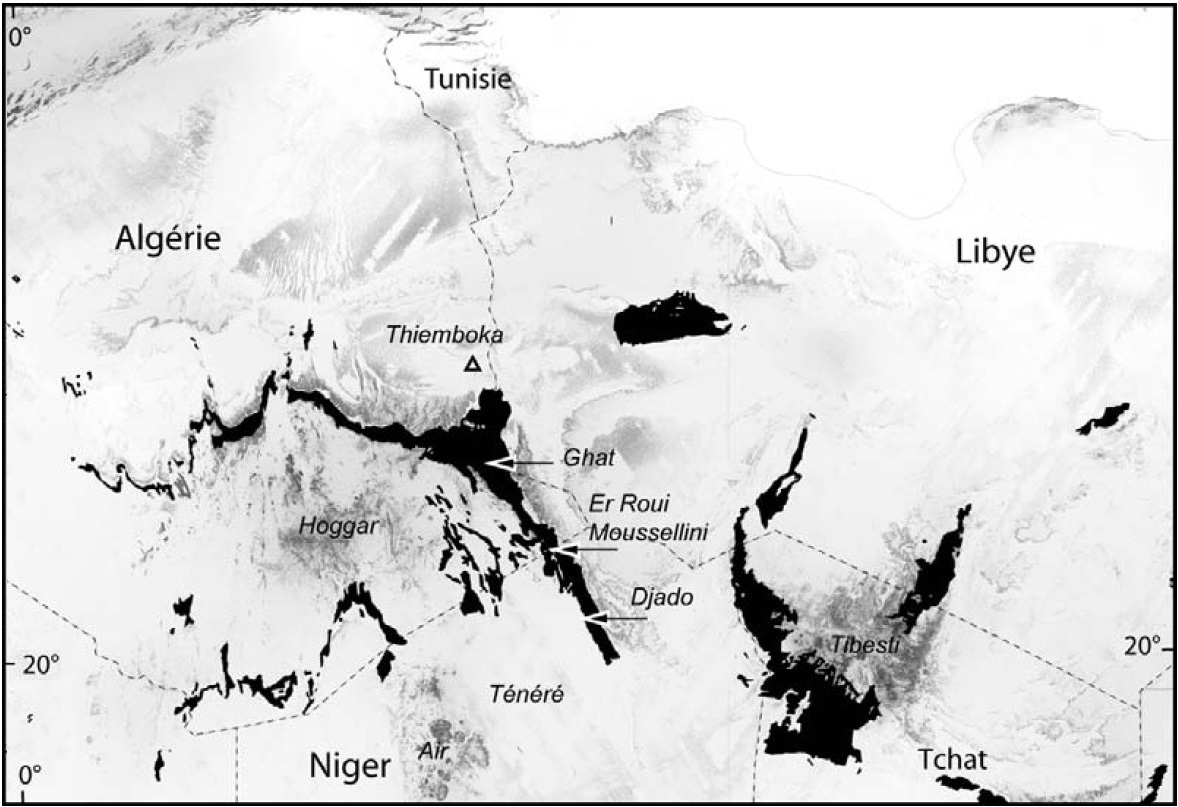
[Figure 6: Outcrops of the Ordovician formations in Niger and surrounding countries (Sources: modified from Buoncristiani et al., 2008)]
GeoJSON
Fossils
Graptolites (Glyptograptus (Glyptograptus ?) ojsuensis Koren & Mikhailova; Normalograptus ojsuensis; Metabolograptus ojsuensis – all synonymy); Inarticulated brachiopods; Trinucleidae trilobites, bivalves and orthocones (Nautiloid cephalopod)
Age
Depositional setting
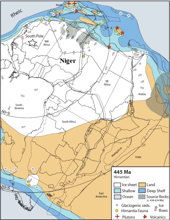
Glacial, periglacial, Glacio-marine, fluvial channel infill (Fig. 7)
[Figure 7: The paleogeography of the central Gondwana area near Ordovician–Silurian boundary time at 445 Ma, shows the glacial and peri-glacial features of the Hirnantian glaciation (Source: Hinsbergen et al., 2011)]
Additional Information
Because the name of “Chirfa Formation” and the locality that corresponds to it have been formally described by Legrand (1993), and since this is a name and location within Niger (contrary to Felar-Felar Fm which relates to a name/location in Algeria hundreds of km away), it was opted to keep the name of Chirfa Fm for this Ordovician rock interval in the Djado Basin.